Welcome to Plummer’s Hollow

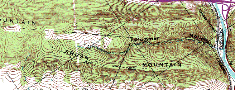
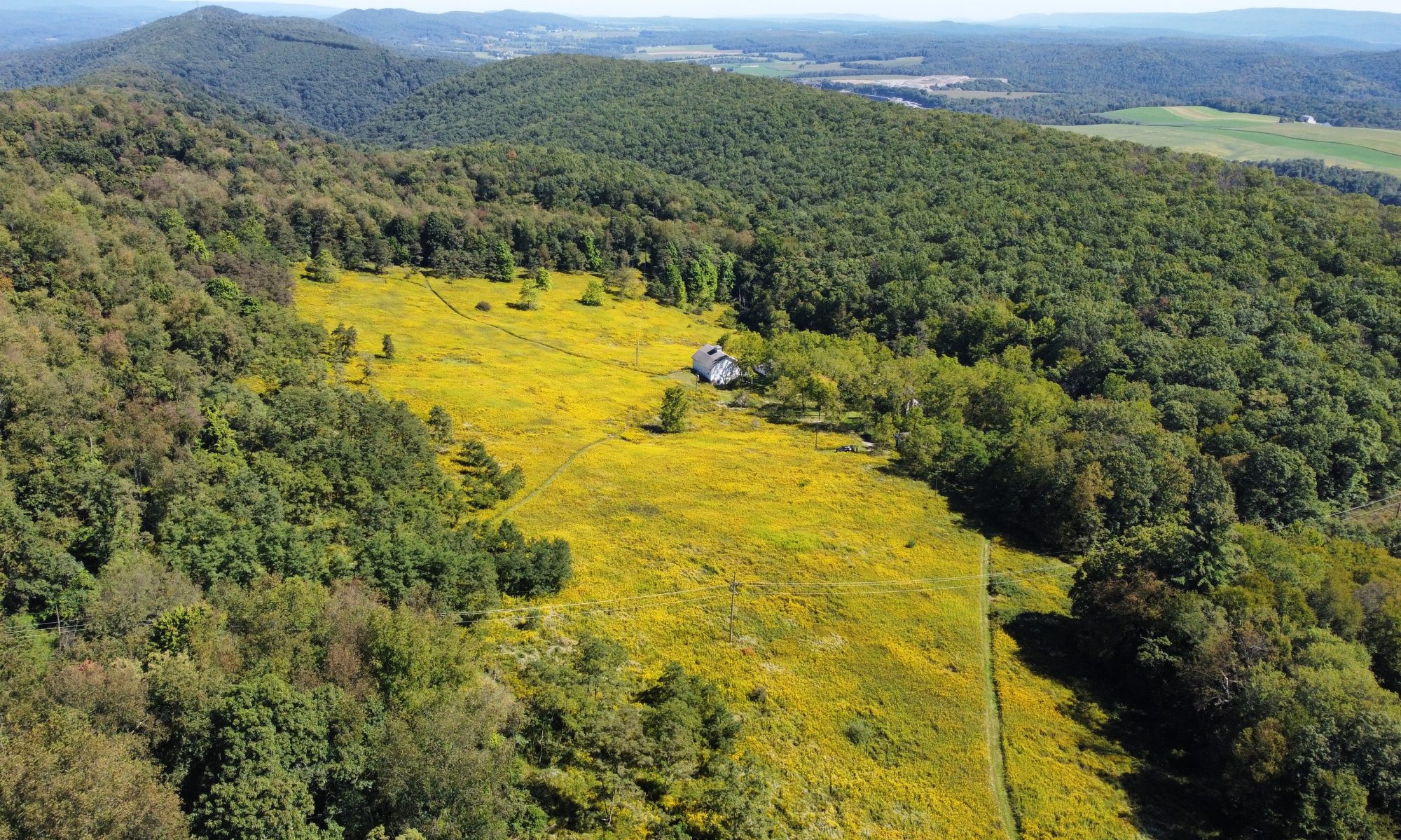
The Plummer’s Hollow Private Nature Reserve is a 648-acre, mostly wooded property on the northern end of Brush Mountain — part of the Bald Eagle ridge system — near Tyrone, in central Pennsylvania, USA. This is the westernmost ridge in the ridge-and-valley Appalachians, and a major migration corridor for hawks, golden eagles, other birds, bats, and migratory insects such as monarch butterflies and green darners. Plummer’s Hollow Run drains into the Little Juniata River, part of the Susquehanna River watershed. Though geologically speaking we are in the central Appalachians, Plummer’s Hollow is at the northern tip of the cultural region known as Appalachia, and near the northern end of the highly biodiverse ecoregion known as the Appalachian-Blue Ridge forests. The entrance to Plummer’s Hollow is located at 40.665 latitude, -78.23028 longitude.

This property is private, but Plummer’s Hollow Road is open as a trail for hiking, walking, photography, and bird watching; we hope visitors will appreciate the natural beauty of the hollow as much as we do. Birders are encouraged to record their findings on eBird, as checklists for the Plummer’s Hollow hotspot.

Although some Appalachian hollows are purely notional, this one is literally a hollow in a mountain where the two flanking ridges nearly touch at the bottom. This blocks a lot of noise from traffic through the gap, especially when the leaves are out. First-time visitors sometimes say that they feel as if they’re entering another world.


No wheeled vehicles, including bicycles, are permitted on this property without our permission.

Please move off to the stream side of the road if a vehicle approaches.

Littering completely destroys the natural beauty of the hollow. If you see a bit of litter discarded by a thoughtless person who was here before you, PLEASE pick it up and take it with you.

Please respect all wildlife and plants in the hollow, and do not disturb anything.

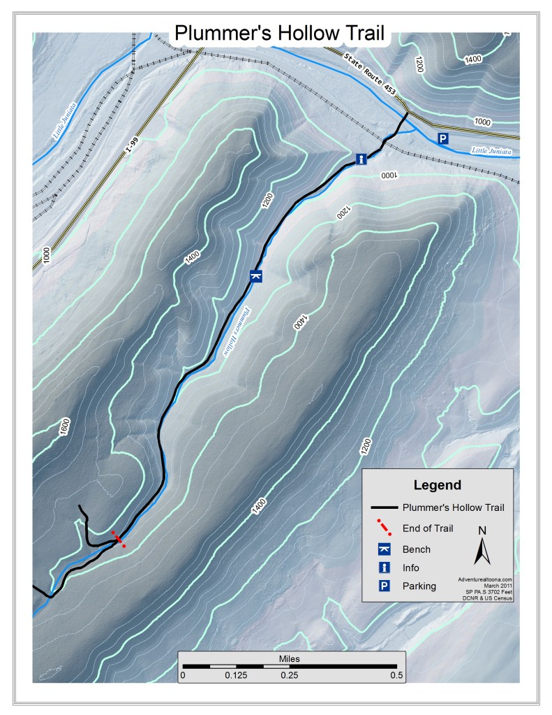
Please respect the privacy of our homes at the top of the hollow. Except for our friends and relatives, whose visits we welcome, we hope others will turn back at the fork in the road about a mile and a quarter up the hollow.

This property is open for hunting by written permission only.

Trapping, shooting, and building fires are not permitted.

Please do not forage for edible/medicinal plants or fungi, dig for old bottles, etc., without permission.

During the fall hunting seasons, October through January, visitors to the hollow should wear at least some blaze orange for safety.


Visitors can park along the township road below the railroad tracks, or along Route 453, and should exercise caution when crossing the tracks — trains are supposed to signal the crossing, but sometimes the engineers forget. After dark, the township road may harbor unsavory characters, but to date, only one body has turned up in the river. So it’s relatively safe, we believe.


Discover more from Plummer's Hollow, Pennsylvania

Subscribe to get the latest posts to your email.

Friends of Plummer’s Hollow

Interested in seeing more of Plummer’s Hollow than just the portion of the road open as a public trail? We’ve launched a Friends program to recruit volunteers to help plant trees and shrubs, remove invasive species, construct deer enclosures, and assist with controlled burns and other ecological recovery efforts in pursuit of our stewardship goals. In return, Friends are allowed to roam anywhere on the property, using our extensive network of trails. Please get in touch if you’re interested in joining. (If you prefer postal mail, write to us: Dave and Marcia Bonta, PO Box 68, Tyrone, PA 16686.)

We are also open to visits from school groups and church groups, elder hostel-type programs, and that sort of thing. And biologists, ecologists, professors of forestry and other scientists looking for places to conduct field research are encouraged to get in touch. (A couple of studies have already taken advantage of our three-acre deer exclosure, in place in an older section of woods since 2001.)

Deer Management Program

Control of the white-tailed deer population is central to our management goals for the property. The property has been posted for Hunting by Written Permission Only since 1992, when we acquired the last, 120-acre parcel in the hollow allowing us to consolidate ownership of the watershed. Though it may seem counter-intuitive, we have found that a few, really good hunters are able to take off many more deer than the throngs of people who used to hunt here in the past. Our hunting program has significantly improved the health of the forest, allowing for much more oak recruitment and the recovery of a number of less common shrubs and wildflowers. Since about 2015, deer numbers have also declined significantly due to CWD and/or the Game Commission’s response to it, and while we’re not sad to see native trees and shrubs get a bit of breathing room, CWD is a terrible disease and we hope the deer herd recovers soon. In the meantime, hunting up here is going to require a lot more persistence than it used to.

We are in the DMAP program, allowing us to secure additional antlerless tags that may only be used on this property.

Hunting Program Rules

  • Hunters in the program must follow all PA game laws
  • Hunters in the program must be willing to kill antlerless deer
  • No lead ammunition, ever
  • An annual fee of $50 per year per adult hunter or unaccompanied minor. Children of permitted hunters are encouraged to learn to hunt here
  • Wild turkey and gray squirrels may also be hunted; ask permission before hunting anything else
  • No varmint shooting 
  • No trapping
  • Only portable tree stands may be used – nothing permanently nailed or bolted in
  • Any tree stand left in the woods may be used by any hunter in the program, but they must vacate it if the owner shows up
  • Trail cams may be placed in the woods at your own risk (of theft, destruction by bears, etc.) but please don’t place them within easy visibility of any of the trails
  • Hunters in the program may bring a friend along, for free, during regular firearms deer season only. They may only shoot antlerless deer, must follow all our rules, and should remain near the permitted hunter (with exceptions by prior arrangement)
  • At the end of the season, let us know how many deer you harvested

If you would like to be considered for the hunting program, please reach out using the form below.

Where and What is Plummer’s Hollow?

Where is Plummer’s Hollow? In fact, what is a hollow in Pennsylvania terms?

Many maps (including Google) still show the Tyrone Sewage Treatment Plant at its old location at the base of Plummer’s Hollow. It moved a quarter-mile downriver to Nealmont in the early 1970s.

First, location. Plummer’s Hollow, which is depicted on the U.S. Geological Survey (USGS) topographic map of the Tyrone Quadrangle, is located in northern Blair County, Pennsylvania. (Note that the USGS routinely simplifies place names by eliminating possessive forms: thus Plummer’s Hollow — its true name — becomes Plummer Hollow.) It is in the southern portion of Snyder Township immediately to the east of the borough of Tyrone. The hollow is formed by a division of Brush Mountain at its northeastern end where the mountain is divided from the southeastern end of Bald Eagle Mountain by the water gap of the Little Juniata River.

A relatively soft rock strata, the Juniata Formation, lies between two harder rock formations, the Tuscarora Formation on the northwest and the Bald Eagle Formation on the southeast. The harder rocks form the crest of Bald Eagle and Brush Mountains, while the softer Juniata Formation breaks down into hollows and dips along the tops of the ridges where settlers discovered it was possible to grow orchard crops. Where these formations are cut by river gaps, transverse hollows tend to develop in the Juniata Formation leading up away from the river gaps; at the Little Juniata River gap, an especially fine example occurs on the south side of the gap, dividing the end of Brush Mountain into two distinct ridges and providing easy access up a small stream (Plummer’s Hollow) to the top of the mountain.

Fog hides the entrance to Plummer’s Hollow; only the Sapsucker Ridge side is visible in this shot, taken on Pennsylvania Avenue in Tyrone

Hollows are common local geographical features in south central Pennsylvania. They may range from very small areas of a few hundred acres to much larger hollows amounting to over a thousand acres. Many are referred to locally but their names don’t even appear on the topographic maps. The actual definition of a hollow appears to be, in the parlance of northern Blair county, a place within the drainage of a small stream. Some groupings of rural homes are referred to as hollows even though they are not really in a distinct watershed, such as the cluster of houses in Sinking Valley which is referred to as Gurekovitch Hollow — a group of homes built by and for the descendants of the original Gurekovitch family. Larger hollows, such as Reese Hollow in Centre County, may have many residents who are unrelated to Reeses. Hollows are not large enough to form political units such as townships, and at least in Blair and Centre Counties many of the hollows are too small even for named villages.

The hollow, in Blair County, is a reference point of local rural residence and identity. We define Plummer’s Hollow as the entire drainage basin of the Plummer’s Hollow Run, an area of approximately 500 acres, although in actual family usage we tend to say “down in the hollow” to mean “below the houses,” where the field ends and the solid woods begin. It is bounded by Sapsucker Ridge, our name for the northwestern ridge of Brush Mountain, Laurel Ridge, the southeastern ridge, and, of course, the Little Juniata River. It rises from 900 feet above sea level to 1660 feet at the top of the watershed.

foamflowers along Plummer’s Hollow Run

Facing northeast as it does, and serving as an echo chamber for the frequent trains wailing through the gap on the east-west trunk line of the old Pennsylvania Railroad, Plummer’s Hollow seems to satisfy most of the requirements of the classic “cold and lonesome holler” of Appalachia. Its name reflects our shared tradition with this most misunderstood and put-down region of the United States. Many other local slang expressions and customs remind us that, while we may inhabit the central Appalachians in a geological sense, in terms of human geography Plummer’s Hollow lies right about at the northern terminus of Appalachia. We are pleased and humbled to think that some of the families hunting and roaming our woods may have local roots that go back over 200 years. It is our sincere wish that all Americans may, in time, develop similar ties of affection and deep familiarity with the wild lands they call home.

Who we are

photos link to our respective websites

Marcia Bonta
Paola and Mark Bonta
Dave Bonta
Eric Oliver